Tuesday Feb 17, 2026
Tuesday Feb 17, 2026
Saturday, 29 July 2017 00:19 - - {{hitsCtrl.values.hits}}
 By Aysha Maryam Cassim
When the journey towards Kandy is made from Colombo via the A1 road, a delightful scenery is met within Kadugannawa Pass, overlooking the Bible Rock. The grandeur of the view at the vantage point tempts the traveller to pull over and immerse himself with the peace and quiet of the surroundings with corn on the cob or a king coconut.
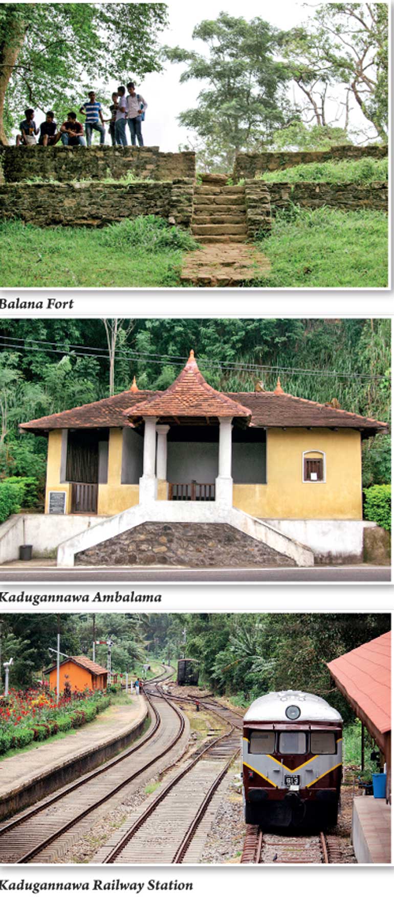
Kadugannawa Ambalama
Kanda Uda Rata, the central highlands, lies 1,727 ft above sea level. The road from Colombo to Kandy by Kadugannawa is a distance of 72 miles, connected by several bridges, the largest of which are those over Mawanella and Mahaweli River.
Those days, people had to ascend the hills with enormous difficulty. The route which had to be traversed was merely a narrow footpath, winding through dense jungles shrouded with thorny bushes on rocky boulders. One could imagine how arduous the journey uphill might have been for the old Ceylonese traveller once upon a time.
The Ambalama in Kadugannawa lies right before the Kadugannawa Pass. When you are coming from Colombo, it’s on the left, lined with the street side dodol and fruit stalls. The Ambalama is said to have been built during the reign of King Sri Wickrama Rajasinghe in the 18th century. This wayside rest house must have been a popular stopover for wayfarers, merchants, pilgrims and horsemen who needed a respite from their long walks.
The Department of Archaeology restored the building in recent years, maintaining the original architectural features of the Kandyan Era.
Alternative routes
From Kurunegala, we proceeded along Colombo road and turned left at Dambokka junction to reach Rambukkana town. Then, we took the scenic Pinnawela road, which meets the main Colombo-Kandy road at the end. As you pass Mawanella town you will reach Kadugannawa.
A1
The Colombo-Kandy highway remains amongst one of the greatest engineering feats in the Colonial history of Ceylon. It’s a solid testimony to British skill and ingenuity which made inland navigation between Kanda Udara and Colombo possible.
Before the British accession, the intercourse between the interior and sea coast was barred due to political motives. Even though the British annexed the Kandyan kingdom in March 1815, their administrative failures resulted in a rebellion in 1818. After this rebellion, the Governor Edward Barnes realised that it was imperative that he tightened security measures in order to take full control of the hill country.
He appointed Captain Dawson to execute the task of constructing a short and direct route that connected Colombo to Kandy. The Barnes administration foresaw the beneficial results which good roads would afford. His vision was carried out into effect with laborious efforts that are duly appreciated even today.
“The exportation of gram, coffee, jaggery and arecanut from the Kandyan provinces and the returns of salt, salt fish and piece of goods constitute the principal object of the internal trade; which was not formally very considerable, owing to the want of regular roads, and also the restrictions and custom duties which were in force when passing from one district to another in the interior” – ‘The Ceylon Gazetteer’ by Simon Casie Chitty Modliar.
Prior to the British conquest, there were no regular roads in the island that connected the hills to the coast. Trade routes in the island extended from Colombo, Northward and Southward to cities as far as Jaffna, Chilaw and Galle. But these roads were not fitted for the wheeled carriages. Agricultural produce and other merchandise had to be conveyed on the backs of cattle known as “thawalama”).
When the country was ceded to the British crown, aforementioned impediments were gradually removed. During his 17-year administration, Sir Edward Barnes constructed roads and facilitated communication and commerce between the coast and the interior. Roads stimulated exertion of the inhabitants. Native farmers were able to transport the produce of their labour to the markets and exports from the interior to Maritime Provinces rapidly increased, prospering Ceylon’s economy in the 1830s.
Captain Dawson
Captain William Dawson Francis was the commanding royal engineer during the government of General Sir. Edward Barnes. He was the mastermind behind the A1 road construction and many other works of public utility. Having studied the terrain, Captain Dawson initiated the A1 project in 1820, phase by phase. He surmounted disasters and diseases battling against monsoons and malaria during this period.
In 1831 the first mail coach left Colombo and went along the new road to Kandy. Unfortunately, Captain Dawson wasn’t fortunate enough to live to witness this triumphant moment. He died on 28 March 1829, before the completion of the construction work. It is said that he had been bitten by a venomous snake.
‘Gala Vidapu Thena’ – Kadugannawa Pass
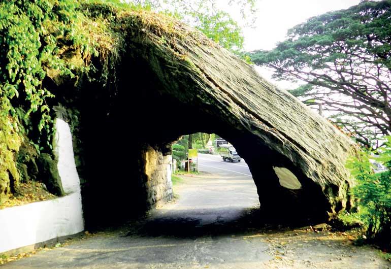
As you go up the Kadugannawa incline, along the hairpin bends and sharp gradients, you will have to pass through a tunnel. This passage is pierced into a cliff to form the tunnel, wide and high enough for a van to drive through. Kadugannawa pass stands witness to Captain Dawson’s technical expertise and deft skills.
Dawson Tower
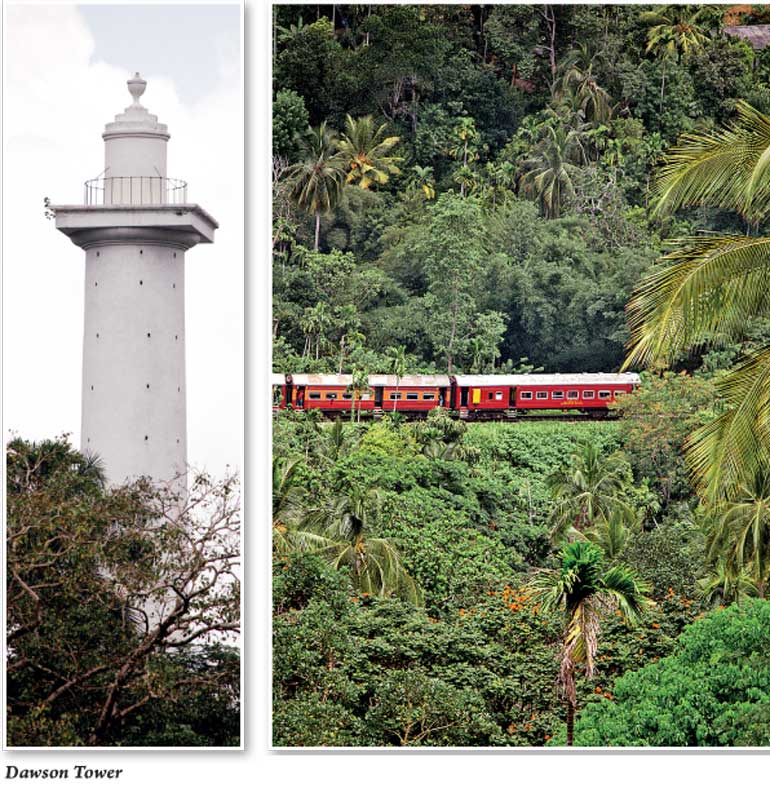
Few metres away from the Kadugannawa pass, you’d find the Obelisk known as Dawson Tower. It was erected in 1832 as a posthumous memorial to Captain Dawson’s exemplary service to the country.
Balana Fort – The Watch Tower of the Kandyan Kingdom
Balana Rock Fort served as the strategic watch tower of ancient Kandyan kingdom. Known as Balana Kotuwa today, the “look out” post has been the ground for many bloody battles in the history of Ceylon.
To get to Balana Fort, you have to come to the town and travel about five km on the Poththapitiya Road which begins near the Kadugannawa Railway Station. The trek up to the fortress is surrounded by tea estates, coffee and spice gardens. The fortress is perched near the Alagalla mountain range, giving you a panoramic view of Mawanella, Kadugannawa, spanning across Bathalegala and Ura Kanda.
Although the historical premise is managed by the Archaeological Department, Balana Fort has turned into crumbling remnants today. The site is badly in need of restoration.
Balana is the narrowest pass in the “Senkadagala” region, secluded and secured by natural barriers that were hardly impenetrable to the foreign invaders. When the Portuguese landed in Sri Lanka in 1505, they wanted to wield their power across the island, acquiring more and more territories. By 1600s, they were in possession of the coastal regions except for the central highlands. The Portuguese intensified their efforts to capture Kanda Uda Rata through various negotiations, rebellions and warfare.
In 1602, King Wimaladharmasooriya instigated a war with Portuguese Commander-in-Chief Simao Pinhao, whose object was to secure Balana. In 1603, Balana was attacked by Portuguese troops. But they had to abandon the city and retreat when the natives deserted them.
Balana Fort was the stronghold of Kadugannawa range during the period when the Portuguese war against Kandy was intense. King Wimaladharmasoriya aka Konappu Bandara, who ruled the Kandyan Kingdom at that time, successfully unified his territory, defending upcountry against the Portuguese invasions.
National
Railway Museum
Kadugannawa Railway Station is located on the side of the Colombo-Kandy Road. It was completed in 1832, 30 years before the railway line was built. Sri Lanka Railways opened the National Railway Museum at Kadugannawa on 27 December 2014 to commemorate the 150th anniversary of the first train run.
The museum is located right behind the station where you’d find classic locomotives stationed on the front yard. Gaze into the old carriages and take a glimpse into the history of trains that links its rails with our colonial past.
The National Railway Museum is open on weekdays from 9am-4pm and weekends from 9am-5pm. Closed on Poya days. The entrance fee is Rs. 50 (Rs.500 for travellers) and it’s given to the passenger as a souvenir railway ticket.

