Thursday May 07, 2026
Thursday May 07, 2026
Friday, 25 September 2015 00:00 - - {{hitsCtrl.values.hits}}
The location map of the proposed Jaffna Expressway after former president Mahinda Rajapaksa laid its foundation stone in November 2014, as released by the Highways Ministry
By Tudor Wijenayake
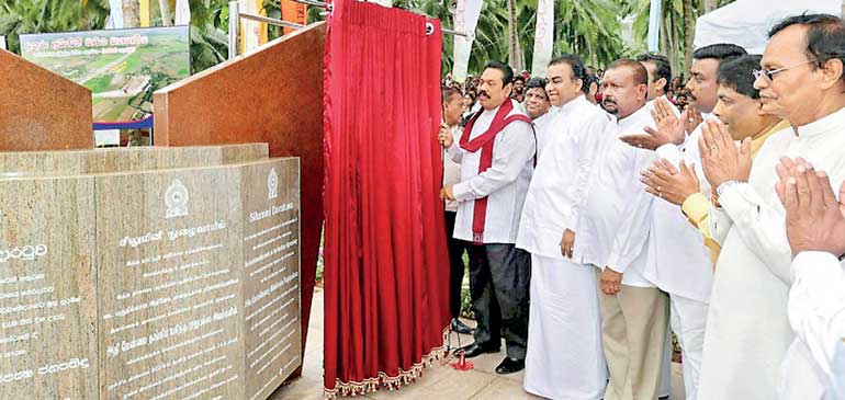
The construction of the expressway connecting Colombo with Kandy was inaugurated again by Prime Minister Ranil Wickremesinghe on 3 August, when he unveiled a plaque at Kossinna, 5 km north of Kadawatha.
The public were informed that the construction of the first section of the expressway had been offered to the Metallurgical Corporation of China, funded by a loan from China’s Exim Bank. The negotiated cost of the 32.5 km-long Kossinna-Mirigama section stands at Rs. 145.8 billion or Rs. 4.5 billion per kilometre. The construction of the expressway had been inaugurated on a number of previous occasions before as well.
It needs to be recalled that immediately after the 8 January elections, a Minister stated that the Government had decided to suspend the execution of the Northern Expressway Project initiated by the previous regime, until its cost-effectiveness was fully checked.
Cabinet approval
The foundation for the project was based on the acceptance of a Cabinet proposal made by the Prime Minister, to approve the appointment of procurement committees, negotiation committees and loan negotiations based on the recommendations by the Cabinet Subcommittee on Economic Affairs to accelerate the commencement of the expressway.
The project is divided into four parts and will be funded by different sources.
1. Kadawatha to Meerigama - with a loan from China EXIM Bank.
2. Meerigama to Kurunegala (with the Ambepussa link) - with a loan from ADB.
3. Pothuhera to Kandy - with a loan from JICA.
4. Kurunegala to Dambulla - through local contractors with funding through a local bond issue.
The Government communicated that the length of the road from Kadawatha-Kurunegala-Kandy would be 99km, which is incorrect.
Early attempts
The Colombo-Kandy Expressway was first proposed in the early 1990s, taking a route over the Kelani River’s northern flood plain and was challenged over environmental issues; with accusations being made that a dam was being built, creating floods. The RDA was unable to suitably answer the accusations and the proposal had to be abandoned.
Feasibility study and environmental acceptance
A feasibility study for the project was completed in December 2001 by a Swedish consultancy firm in association with a local consultant. During the near-decade of review, many changes were made to the original proposal and Environmental Impact Assessment (EIA) clearance was granted by the CEA for the trace in May 2008.
According to CEA-accepted proposals, the expressway was to commence from the Kadawatha interchange of the Outer Circular Highway and end in Katugastota. The proposed 3-km-wide corridor runs close to Ganemulla, Gampaha, Balabowa, Banduragoda, Mirigama and Ambepussa (Phase 1 - 48.2km) and Devalegama, Rambukkana, Hatharaliyadda, Hedeniya and Katugastota (Phase 2 - 50.7 km).
Offer to investors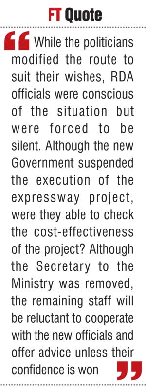
The proposed highway was offered to international investors in May 2011, to be built as a privately financed toll road on a BOT (build, own and transfer) basis. The investor was expected to design the road over the preselected corridor, acquire land, pay compensation and construct related facilities. The design and construction would be conducted under the supervision of a reputed international consultancy firm.
Under the proposal’s Phase 1, the Kadawatha-Ambepussa sector would have four lanes with the option of 2 additional lanes for future expansion, allowing speeds of 100 kph. Phase 2, from Ambepussa-Devalagama-Katugastota, also had four lanes with a connecting link to Gannoruwa, making the total length 98.9 km. The highway beyond Devalagama would only allow a speed of 80 kph due to terrain restraints.
Award of contract
In July 2012, the construction of the 100-km Kandy Expressway was awarded to two Chinese companies: China Merchant Holdings and China Merchant Huajin Investment Company. The China Merchant Huajin Investment Company’s website mentions the project under an article entitled ‘China Company lands 1 Bln USD highway project in Sri Lanka’.
The article says: “China Merchant’s Group earmarked to build a 1 Billion U.S. Dollar expressway that will kick off later this year. The construction of the first phase of about 48 km is expected to begin in August and will be done under the Build Own Transfer (BOT) system. Highways Ministry Secretary Ranjith Premasiri told Xinhua that ‘The feasibility study has been completed and a Memorandum of Understanding (MoU) has been signed with the company. We are discussing details of tax holidays and land allocation presently’.”
Protests and diversion
In July 2012, the villagers of Walpola and Batuwatta, near Gampaha, demanded that the expressway not run through their villages and disturb the social links of the people and endanger the natural environment.
The protesters dispersed after Minister Felix Perera assured villagers that the expressway would be diverted through Narangodapaluwa. Accordingly, the beginning of the highway was changed from Kadawatha to Enderamulla and joined the original route at Mirigama. The shift increased the highway length by 3 km.
Enderamulla is surrounded by marshes and the amended route ran mostly parallel to the railway line, traversing over paddy, marshy and uncultivated lands. Most of the 15 km diversion runs on poor ground and 9 km of the road had to be converted to a viaduct (overhead road). Viaducts cost over six times the cost of a normal road and the increased costs altered the financial viability of the project and the Chinese investor was no longer interested.
Changes to Kandy route
In March 2013, Mahinda Rajapaksa, during a visit to Kandy, reviewed the progress of the expressway project. Observing that problems over land acquisition in Kegalle and Rambukkana had caused delays in the implementation of the project, Rajapaksa directed the expressway to be built through Kurunegala and Galagedara.
None of the RDA staff present dared to explain to the President that diverting the road from Ambepussa to Kurunegala would push the highway nearly 20 km northwards and would increase the highway’s length, thereby increasing its cost.
Inauguration of Northern Expressway
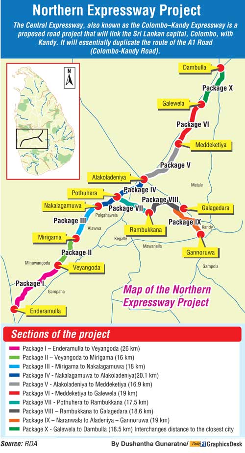
In November 2014, Mahinda Rajapaksa launched the construction of the expressway by laying a foundation stone at the Senkadagala entrance of the expressway. The proposal intends to connect Enderamulla to Galewela on the Dambulla road with a link-highway from Pothuhera to connect Katugastota and Gannoruwa.
The Enderamulla-Galewela section will have interchanges at Gampaha, Veyangoda, Mirigama, Nakalgamuwa, Pothuhera, Dambokka, Kurunegala, Rideegama and Melsiripura. (Please see attached map, prepared by RDA)
The link highway from Pothuhera to Gannoruwa will have interchanges at Rambukkana, Galagedara, Naranwala, Katugastota and Gannoruwa. Distance-wise Enderamulla to Pothuhera is 67.8 km and Pothuhera to Gannoruwa will be 52 km, making the total distance of the expressway from Enderamulla to Kandy 120 km.
RDA’s Highway Master Plan
RDA’s National Road Master Plan (2007-2017) showing the proposed expressways, indicate the Anuradhapura-Jaffna expressway being an extension of the Katunayake highway and the Kandy expressway commencing from the Kadawatha exit of the Outer Circular Road. The master plan shows the highway passing the Gampaha, Veyangoda and Mirigama route to Ambepussa, indicating the influence of former Highways Minister Basil Rajapaksa in modifying the proposal of Swedish consultants.
Revised Kandy Expressway
Ranil Wickremesinghe’s Cabinet proposal modified the commencement of the project back to the original location of Kadawatha from Enderamulla, with the rest remaining unchanged from the Rajapaksa amended proposal through Pothuhera (Kurunegala); the modification reduced the distance by 3 km.
Along with the change of the starting point to Kadawatha, the first 5 km of the highway from Kadawatha to Kossinna was offered to the Chinese contractor engaged in the Outer Circular Road Section 3 (OCR 3). The new arrangement proposed to offer the 35 km Kossinna-Meerigama sector to the Metallurgical Corporation of China.
Changes to OCR 3
The six-lane 9.32 km-long-OCR 3 from Enderamulla to Kadawatha runs mostly over marshes. The widening of the road to six lanes was mostly done to accommodate additional traffic expected from Kadawatha (from Colombo and the Southern Highway) to join the Northern Highway, commencing at Enderamulla.
Shifting the highway back to Kadawatha enabled the deletion of the additional two lanes; the reduced cost of OCH 3 and the savings were transferred to construct the 5 km Kadawatha-Kossinna section.
The shifting will help motorists by reducing their travel distance. As most vehicles begin or end their journeys in Kandy they will travel either to Colombo or continue along the Southern Expressway, reducing the distance they will have to travel by 9.32 km.
ADB loan
According to the proposal, the Meerigama-Kurunegala section with the Ambepussa link is to be built with ADB funding. But Sri Lanka’s past experience with ADB indicates that the document preparation to satisfy ADB requirements, which includes detailed plans, specifications, addressing environmental concerns, relocation of affected persons, calling of tenders, evaluation and award of tender, etc. will take a minimum of four years. With a construction period of three years, the completion of the road section would require seven to eight years. Meanwhile, others sections would be completed much earlier.
It needs to be noted that the EIA-accepted route in May 2008 was Kadawatha-Ambepussa-Katugastota. Current proposals have varied from the accepted route and would require fresh EIA acceptance.
The route map
The RDA’s route map shows how the road has been deliberately moved away from the A 1 route to pass through Gampaha, Veyangoda, Mirigama and continue northwards, crossing the Maha Oya close to Narammala prior to turning eastwards (the junction before Kurunegala is referred to as Pothuhera) taking a twisted path to reach Gannoruwa, a total length of 117 km from Kadawatha. The road traverses a route well beyond the British-built railway line.
The route map indicates that the shortest route to Kandy would be almost parallel to the existing road. The A 1 road to Kandy consists of two straight sections with a slight turn at Ambepussa. Distance-wise Kadawatha to Ambepussa is 40 km and Gannoruwa is 95 km away. But according to the highway plan, Kadawatha to Ambepussa is 48.2 km, longer by 8.2 km. In a proper design, the distance could be reduced to 38 km by avoiding twists and turns on the existing road.
As the crow flies, Ambepussa-Gannoruwa is 38km. As such, it should be possible to construct a properly designed highway which is less than 45 km, even if the mountains are considered, especially considering that the proposed road has 20 km in tunnels, which will give a total highway length of 83 km.
The current route is 34 km longer. In addition the route passes over paddy fields and marshes, requiring over 10 km of viaducts (elevated roads), massively increasing costs.
Access to Kurunegala
According to the earlier plan, the Ambepussa-Devalagama sector was designed for a speed of 100 kph speed and beyond is 80 kph due to the winding road. Extending the highway 18 km northwards from Devalagama would meet Kurunegala and could continue to Galewela and Dambulla, the cheapest option.
Motorist’s point of view
If the Kandy highway were to be built through Kurunegala (Pothuhera) as presently planned, distance over the highway would be 117 km versus 101 km on the A1. Some motorists would take the highway, reducing the congestion on the Kandy road. With a shorter distance of 16 km saving fuel and without toll charges (around Rs. 1,000 one way), a substantial number of motorists will continue on the existing road, even if the drive takes one hour extra, leading to reduced toll collections, completely altering financial projections.
Checking cost-effectiveness
While the politicians modified the route to suit their wishes, RDA officials were conscious of the situation but were forced to be silent. Although the new Government suspended the execution of the expressway project, were they able to check the cost-effectiveness of the project? Although the Secretary to the Ministry was removed, the remaining staff will be reluctant to cooperate with the new officials and offer advice unless their confidence is won.
The way forward
The Kadawatha-Kandy route has the heaviest traffic in Sri Lanka and would interest international investors, as already demonstrated by the Chinese and Malaysians. The prospective investor would finance, design, construct, maintain and operate the expressway and even widen the highway as needed to accommodate increasing traffic, under the Build Own Transfer (BOT) system, collect toll for an agreed time period and transfer the project to the Government.
Normally, the period would be around 35 years. As such, the investor will have to ensure quality and maintain the road properly.
At a time when the country is pressed for finances, finding an investor would be the best option. To interest foreign investors, the project cost should be lowest and attract a maximum number of toll paying users. Currently, the proposed highway through Kurunegala is the longest, costs the most and will fail to attract some of the motorists.
The present Kandy Expressway route has been botched by the politicians, who have extended the highway length by 34 km, resulting in an additional cost of over Rs. 150 billion which needs a technical review. For selecting the most suitable route, the basis could be the Swedish consultant’s original proposal. EIA acceptance needs to be obtained for a 3 km wide corridor as previously obtained, would allow sufficient room to manoeuvre, avoiding marshes requiring viaducts. The final route selection, design details would be best decided by the investor, within the accepted road corridor supervised by a reputed consultant.
Selecting a shorter route corridor based on the available data would be possible in three months and EIA acceptance in six months. After selecting the investor and signing an agreement, an efficient investor would commence work within three months and complete the construction in three years. A zero cost expressway to Kandy, in less than five years would be a win-win situation for the people of the country.

